Welcome Geology Students!

Finding yourself on a topographic map #1

Navigating Topographic Map #1

Goal

Background on Mt. Cleveland

Position with triangulation

What to turn in and how

Goal

Geologists use topographic maps. Geologic maps are often made on topographic base maps. That is, the geology and geologic features are plotted on a contour map of the topography. So, it is is critical for geologists to understand how to use topographic maps. In the next couple of exercises we will use topographic maps and information to locate points on the map and to infer features about Mt. Cleveland volcano and its neighbors. This exercise involves triangulation using compass bearings.

Mt. Cleveland volcano

Mount Cleveland is a volcano in the Aleutian Islands, an archipelago that extends west from the Alaska mainland.The Aleutians are a volcanic arc, formed from the subduction of the Pacific Plate beneath the North American plate. Volcanoes form the arc, that stretches hundreds of kilometers across the northern Pacific.

Mt. Cleveland is one of the most active volcanoes in North America. It is monitored by the Alaska Volcano Observatory (AVO), which is operated by the U.S. Geological Survey and the University of Alaska.

Get to know Mt Cleveland

Use Google Earth Pro to locate Mount Cleveland in the Aleutian arc. Notice its position along the arc and note that it is part of a group of volcanoes that form four islands.

Check out the live webcam that AVO has set up to monitor Mt. Cleveland. if it is cloudy or dark, you can check out their "Clear day image" on the same page.

Check out the Smithsonian webpage about Mt Cleveland and its recent history

Obviously, Mt Cleveland is an active volcano and needs to be monitored. In summer months it is visited by volcano scientists to monitor the volcano and to understand its volcanic history.

Let's consider a team going to monitor Mt. Cleveland...

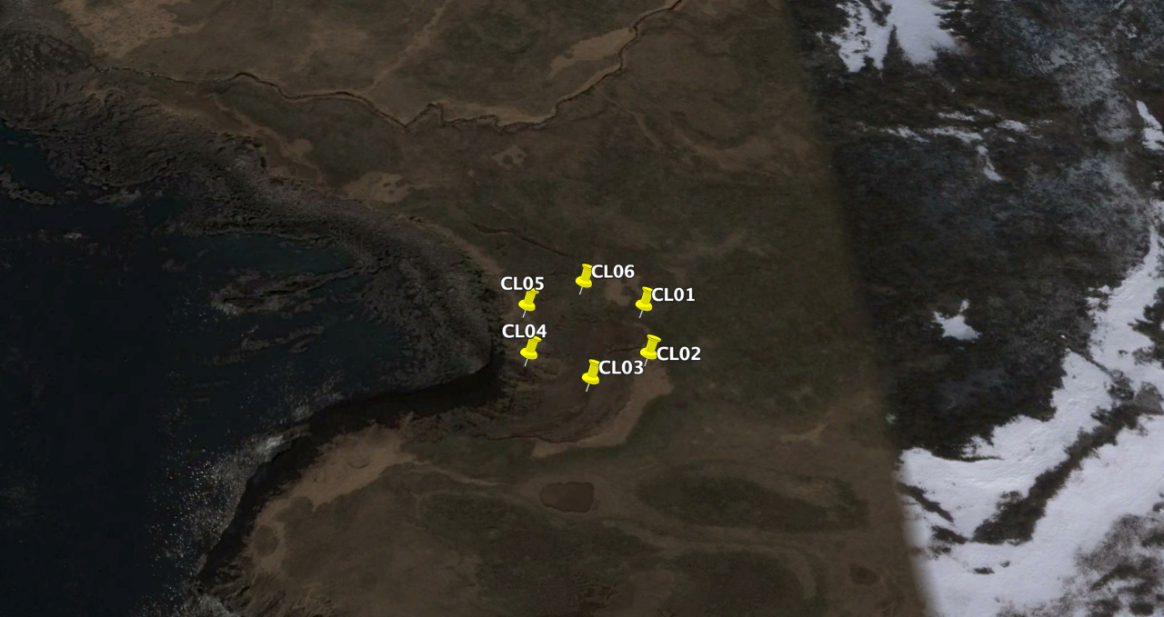
Map position by triangulation

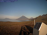
The team is dropped off by helicopter. After unloading they decide to locate their position. It is clear enough (remarkably!) to see three volcanic peaks in the distance. These are: (1) the symmetric and tall peak of Mt Cleveland, (2) the more distant and truncated peak of Herbert volcano to the left of Mt Cleveland, and the hazy peak of another volcano to the right (north) of Mt. Cleveland. This last volcano is called Carlisle volcano, or Mt. Carlisle, but it is not named on some maps.

the view
The (blurry!) view from the landing zone webcam. Mount Cleveland is the center of the three volcanoes. Herbert volcano is to the left.

Now look at the topographic map. Mount Cleveland and Herbert volcano are labeled. The third volcano island NW of Mount Cleveland is not named on the map. The contour interval on the map is 100 m, Mt. Cleveland rises from sealevel to 1730 m (approximately, its height changes with nearly every eruption).

Using the photograph and the map, guess the location of the helicopter drop zone. Consider the relative locations of the three volcanic peaks in the photo from the webcam at the drop zone and the positions of these three peaks on the map.

Your guess might be quite accurate, or you might be off! Improve your guess using bearings to triangulate your location. With a Brunton compass, team members "shoot" bearings from your location to three points. These three points are:

  1. Mt Cleveland summit: 287$^{\circ}$
  2. Herbert volcano east crater rim: 262$^{\circ}$
  3. Carlisle volcano summit (NW of Mt Cleveland, not labeled on map): 299$^{\circ}$

To triangulate the team's position, find the three points on the map. Use the azimuth tool to find the bearing from the point to the team's location. Hint: You will have to subtract 180$^{\circ}$ from the bearing measured from the team's location to the point. The bearing lines intersect at the team's location.

Drag the red circle to move the azimuth tool

Drag the blue circle to change the bearing

read the azimuth (the blue number)

Extra construction lines are OK. But if you make too many just start over by refreshing (reloading) the webpage.

Save the image by right-clicking on the image.

Answer these questions

Make a word document that contains this work:

  1. A *.png image (file) of the map showing the location of the team in the helicopter zone. Remember, right click the mouse over the map to save the file.
  2. What bearing would the team sail to go from the helicopter landing zone to the north beach on the Herbert volcano island? Hint: Since you want to know the bearing from your position to the beach, you do not add or subtract 180$^{\circ}$ from the bearing.
  3. Volcano scientists use a technique called infrasound to monitor volcanoes. It can be quite difficult to know from visual monitoring if a volcano has erupted, especially at night or in cloudy conditions. Yet it is important to know if even a remote volcano like Mount Cleveland has erupted in order to warn airplanes that might be flying nearby. Normally many hundreds of commercial aircraft fly near Mount Cleveland everyday on their way from North America to Asia and back.

    Infrasound monitoring listens to the volcano for the sounds of an eruption. The listening devices are sensitive to very low frequency waves that are produced by an eruption and which can travel great distances without too much attenuation. Often, arrays of sensors are deployed to listen for infrasound signals. With an array it is possible to see the difference in arrival time of the sound wave at different sensors in the array, and calculate a bearing to the volcano that is erupting. There is uncertainty in the bearing because of uncertainty in picking when the sound arrives at each sensor.

    the view
    An example infrasound array your team deploys at the webcam location near Mount Cleveland volcano. The sensors are laid out in a circle. Bearing to the eruption source is found by looking for differences in the arrival times of sound waves at each sensor.

    Suppose your team deploys infrasound arrays at the webcam location and on the north beach of Herbert volcano island. Not long after a volcano erupts and the two infrasound arrays record the eruption.

    the view
    Sound waves from a volcanic eruption recorded by an infrasound array. There is one recording for each infrasound sensor of the "webcam" array.
    1. Based on the peak sound wave amplitude, which infrasound sensor recorded the wave arrival first? Which sensor recorded the arrival last? Based on your observation, what is the approximate direction of sound travel?
    2. Specialists can calculate the bearing of the volcano eruption from the infrasound array based on the differences in arrival time of the sound wave. Using the webcam array data, the bearing to the eruption is between $296^{\circ}$ and $300^{\circ}$. The eruption bearing is between $16^{\circ}$ and $20^{\circ}$ from the Herbert volcano north beach array. Plot these bearings on your map using the azimuth tool. Which volcano erupted? In your answer, include a picture of the map with the bearings plotted.